PITTSBURGH — Tornado Warning for Fayette and Greene County has expired
10:52 p.m.
Red Cross volunteers have been dispatched throughout our area, assisting towns and individuals who have been impacted by the heavy storms our area has seen the past couple of days.
9:42 p.m.
[if gte mso 9]>
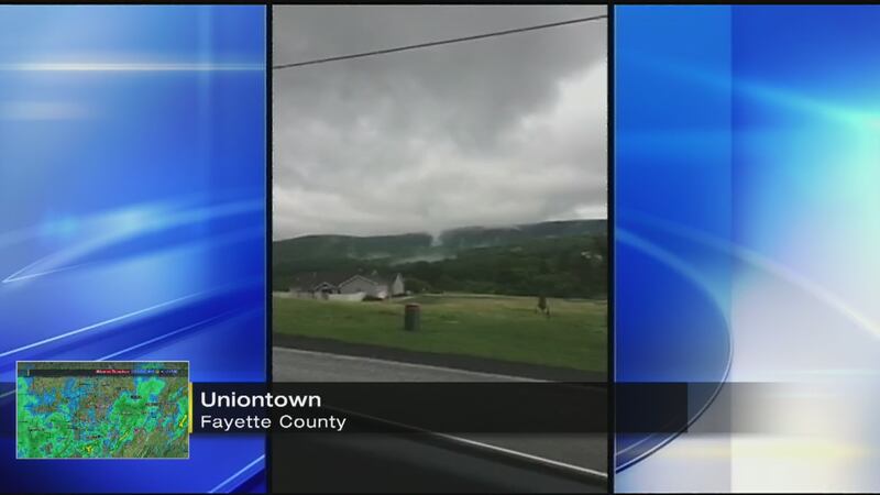
Fayette County has declared a State of Emergency. Local fire departments have requested PennDOT to secure the state roads that are damaged because there are not enough resources to close the roads.
9:20 p.m.
The National Weather Service confirms a tornado did damage trees and buildings in Amwell Township in Washington County.
9:08 p.m.
A state of emergency has been declared in Redstone Township, per the fire chief and township emergency management agency.
8:56 p.m.
Backyards are underwater in the village of Fairbank in Fayette County. Homes have been evacuated along Pala Street.
Pala Street in Fairbank under 2 feet of water. Homes evacuated. @WPXI pic.twitter.com/e3M3mlI3y2
— Mike Holden (@WPXIMikeHolden) June 24, 2017
7:54 p.m.
Fairbank area in Fayette is being evacuated. There is heavy flooding in German Twp., Menallen and Redstone townships. Rescue teams activated. Evacuees are being taken to the Republic Fire Department.
6:10 p.m.
Flash Flood Warning including Moundsville WV, McMechen WV, Glen Dale WV until 10:00 PM EDT
5:50 p.m.
TORNADO SPOTTED near Uniontown. Seek shelter in eastern Fayette County.
5:30 p.m.
A funnel cloud was seen by a trained weather spotter in Pine Bank, Greene County, during a tornado warning Friday afternoon.
-----
(Earlier)
A Severe Thunderstorm Watch has been issued for much of the area through this evening. Strong storms producing 60 mph winds and hail will cross the area through 10 pm. An isolated tornado can't be ruled out.
A Flash Flood Watch remains in effect for much of the area through late Friday night
Significant damage after woman says tornado rolled through Brush Run Road in Washington County. Siding and roof partially ripped off. @WPXI pic.twitter.com/EG6hHWuURs
— Mike Holden (@WPXIMikeHolden) June 23, 2017
Several rounds of heavy rain and thunderstorms will cross the area through late tonight. More than 2" of rain is possible by midnight tonight for parts of the region. Flooding is a concern for many low-lying a flood-prone areas. Watch for ponding of water on roads and potential hydroplaning. Rain will taper off to scattered showers after midnight tonight.
- PHOTOS: Severe weather moves through Pittsburgh region (June 23, 2017)
- VIDEO:Streets Run flooding (6/23/17)
- VIDEO: Indiana County flooding (6/23/17)
The Flash Flood Watch includes Pittsburgh, Greensburg, Washington, Latrobe, Uniontown, Waynesburg, Kittanning, Indiana and Morgantown.
Do not attempt to drive through flooded roadways-"Turn Around-Don't Drown."
STORM TRACKER: Hour-by-hour timing of rain, T’storms crossing region
A Flash Flood Watch is in effect for much of western Pennsylvania through late Friday night.
Several rounds of heavy rain and thunderstorms will cross through the region, with more than two inches of rain possible by midnight in some areas.
Areas under the Flash Flood Watch include Pittsburgh, Greensburg, Washington, Latrobe, Uniontown, Waynesburg, Kittanning, Indiana and Morgantown.
Flooding is a concern for many low-lying a flood-prone areas. The will be the potential for ponding of water on roads and hydroplaning.
Do not attempt to drive through flooded roadways – “Turn Around-Don't Drown.”
Rain will taper off to scattered showers after midnight.
Thunderstorms with heavy rain will bring potential flooding later today.
— Scott Harbaugh (@WPXIScott) June 23, 2017
Weather: https://t.co/3lNA1g4kFS pic.twitter.com/ouJeyss2bC
RELATED STORY: Indiana County hit hard by flooding; 1 man killed
TRENDING NOW:
- WATCH: Cosby juror opens up about what really happened during deliberations
- Teen receives priceless graduation gift from grandmother
- Suspicious package causes evacuation of neighborhood for several hours
- VIDEO: Deer fight caught on camera
Cox Media Group