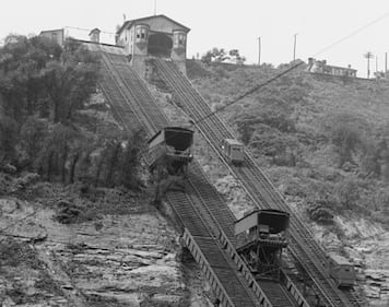
Mon Incline Detroit Publishing Co, P. (1905) Monongahela Incline and adjacent freight incline, Pittsburgh, Pa. Pittsburgh Pennsylvania United States, 1905. [Photograph] Retrieved from the Library of Congress, https://www.loc.gov/item/2016811624/. (Library of Congress)
Mon Incline Detroit Publishing Co, P. (1905) Monongahela Incline and adjacent freight incline, Pittsburgh, Pa. Pittsburgh Pennsylvania United States, 1905. [Photograph] Retrieved from the Library of Congress, https://www.loc.gov/item/2016811624/. (Library of Congress)
Mon Incline Detroit Publishing Co., Copyright Claimant, and Publisher Detroit Publishing Co. Monongahela Incline and adjacent freight incline, Pittsburgh, Pa. Pittsburgh Pennsylvania United States, ca. 1905. Photograph. https://www.loc.gov/item/2016805381/. (Library of Congress)
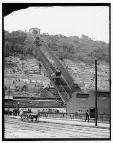
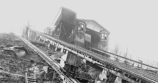
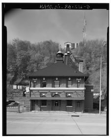
Mon Incline Detroit Publishing Co, C. C. & Detroit Publishing Co, P. P. & L.E. Ry. Pittsburgh and Lake Erie Railroad station and Mt. Washington, Pittsburgh, Pa. Pittsburgh Pennsylvania United States. [between 1900 and 1910] [Photograph] Retrieved from the Library of Congress, https://www.loc.gov/item/2016800533/. (Library of Congress)
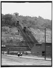
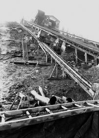
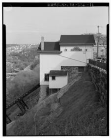
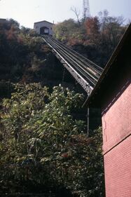
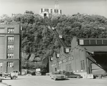
Mon Incline General view of incline supports looking to Mount Washington Roadway, taken on December 13, 1926. The passenger line was built in 1870 and reconstructed of metal in 1882. A parallel plane was added in 1884 to facilitate the hauling of freight. The parallel plane was closed in 1936. (Archives & Special Collections, University of Pittsburgh Library System)
Mon Incline General view of incline supports looking to Mount Washington Roadway, taken on December 13, 1926. The passenger line was built in 1870 and reconstructed of metal in 1882. A parallel plane was added in 1884 to facilitate the hauling of freight. The parallel plane was closed in 1936. (Archives & Special Collections, University of Pittsburgh Library System)
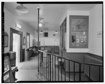
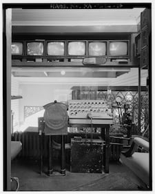
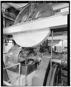
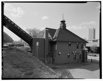
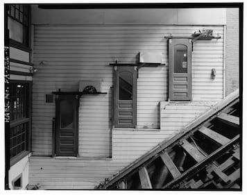
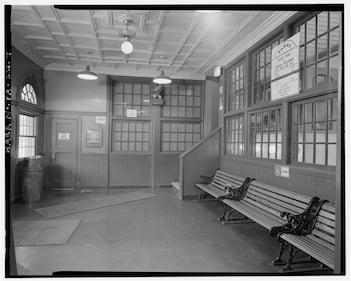
Mon Incline Historic American Engineering Record, C., Endres, J. J., Otis Elevator Company, Acres American, I., Massaro Corporation, Hail Industries [...] Rogers, R. M., Thum, D., photographer. (1968) Monongahela Incline Plane, Connecting North side of Grandview Avenue at Wyoming Street with West Carson Street near Smithfield Street, Pittsburgh, Allegheny County, PA. Pennsylvania Pittsburgh Allegheny County, 1968. Documentation Compiled After. [Photograph] Retrieved from the Library of Congress, https://www.loc.gov/item/pa2667/. (Library of Congress)
Mon Incline Historic American Engineering Record, C., Endres, J. J., Otis Elevator Company, Acres American, I., Massaro Corporation, Hail Industries [...] Rogers, R. M., Thum, D., photographer. (1968) Monongahela Incline Plane, Connecting North side of Grandview Avenue at Wyoming Street with West Carson Street near Smithfield Street, Pittsburgh, Allegheny County, PA. Pennsylvania Pittsburgh Allegheny County, 1968. Documentation Compiled After. [Photograph] Retrieved from the Library of Congress, https://www.loc.gov/item/pa2667/. (Library of Congress)
Mon Incline Historic American Engineering Record, C., Endres, J. J., Otis Elevator Company, Acres American, I., Massaro Corporation, Hail Industries [...] Rogers, R. M., Thum, D., photographer. (1968) Monongahela Incline Plane, Connecting North side of Grandview Avenue at Wyoming Street with West Carson Street near Smithfield Street, Pittsburgh, Allegheny County, PA. Pennsylvania Pittsburgh Allegheny County, 1968. Documentation Compiled After. [Photograph] Retrieved from the Library of Congress, https://www.loc.gov/item/pa2667/. (Library of Congress)
Mon Incline Historic American Engineering Record, C., Endres, J. J., Otis Elevator Company, Acres American, I., Massaro Corporation, Hail Industries [...] Rogers, R. M., Thum, D., photographer. (1968) Monongahela Incline Plane, Connecting North side of Grandview Avenue at Wyoming Street with West Carson Street near Smithfield Street, Pittsburgh, Allegheny County, PA. Pennsylvania Pittsburgh Allegheny County, 1968. Documentation Compiled After. [Photograph] Retrieved from the Library of Congress, https://www.loc.gov/item/pa2667/. (Library of Congress)
Mon Incline Historic American Engineering Record, C., Endres, J. J., Otis Elevator Company, Acres American, I., Massaro Corporation, Hail Industries [...] Rogers, R. M., Thum, D., photographer. (1968) Monongahela Incline Plane, Connecting North side of Grandview Avenue at Wyoming Street with West Carson Street near Smithfield Street, Pittsburgh, Allegheny County, PA. Pennsylvania Pittsburgh Allegheny County, 1968. Documentation Compiled After. [Photograph] Retrieved from the Library of Congress, https://www.loc.gov/item/pa2667/. (Library of Congress)
Mon Incline Historic American Engineering Record, C., Endres, J. J., Otis Elevator Company, Acres American, I., Massaro Corporation, Hail Industries [...] Rogers, R. M., Thum, D., photographer. (1968) Monongahela Incline Plane, Connecting North side of Grandview Avenue at Wyoming Street with West Carson Street near Smithfield Street, Pittsburgh, Allegheny County, PA. Pennsylvania Pittsburgh Allegheny County, 1968. Documentation Compiled After. [Photograph] Retrieved from the Library of Congress, https://www.loc.gov/item/pa2667/. (Library of Congress)
Mon Incline Historic American Engineering Record, C., Endres, J. J., Otis Elevator Company, Acres American, I., Massaro Corporation, Hail Industries [...] Rogers, R. M., Thum, D., photographer. (1968) Monongahela Incline Plane, Connecting North side of Grandview Avenue at Wyoming Street with West Carson Street near Smithfield Street, Pittsburgh, Allegheny County, PA. Pennsylvania Pittsburgh Allegheny County, 1968. Documentation Compiled After. [Photograph] Retrieved from the Library of Congress, https://www.loc.gov/item/pa2667/. (Library of Congress)
Mon Incline Historic American Engineering Record, C., Endres, J. J., Otis Elevator Company, Acres American, I., Massaro Corporation, Hail Industries [...] Rogers, R. M., Thum, D., photographer. (1968) Monongahela Incline Plane, Connecting North side of Grandview Avenue at Wyoming Street with West Carson Street near Smithfield Street, Pittsburgh, Allegheny County, PA. Pennsylvania Pittsburgh Allegheny County, 1968. Documentation Compiled After. [Photograph] Retrieved from the Library of Congress, https://www.loc.gov/item/pa2667/. (Library of Congress)
Mon Incline Historic American Engineering Record, C., Endres, J. J., Otis Elevator Company, Acres American, I., Massaro Corporation, Hail Industries [...] Rogers, R. M., Thum, D., photographer. (1968) Monongahela Incline Plane, Connecting North side of Grandview Avenue at Wyoming Street with West Carson Street near Smithfield Street, Pittsburgh, Allegheny County, PA. Pennsylvania Pittsburgh Allegheny County, 1968. Documentation Compiled After. [Photograph] Retrieved from the Library of Congress, https://www.loc.gov/item/pa2667/. (Library of Congress)
Mon Incline Historic American Engineering Record, C., Endres, J. J., Otis Elevator Company, Acres American, I., Massaro Corporation, Hail Industries [...] Rogers, R. M., Thum, D., photographer. (1968) Monongahela Incline Plane, Connecting North side of Grandview Avenue at Wyoming Street with West Carson Street near Smithfield Street, Pittsburgh, Allegheny County, PA. Pennsylvania Pittsburgh Allegheny County, 1968. Documentation Compiled After. [Photograph] Retrieved from the Library of Congress, https://www.loc.gov/item/pa2667/. (Library of Congress)
Mon Incline Historic American Engineering Record, C., Endres, J. J., Otis Elevator Company, Acres American, I., Massaro Corporation, Hail Industries [...] Rogers, R. M., Thum, D., photographer. (1968) Monongahela Incline Plane, Connecting North side of Grandview Avenue at Wyoming Street with West Carson Street near Smithfield Street, Pittsburgh, Allegheny County, PA. Pennsylvania Pittsburgh Allegheny County, 1968. Documentation Compiled After. [Photograph] Retrieved from the Library of Congress, https://www.loc.gov/item/pa2667/. (Library of Congress)
Mon Incline Historic American Engineering Record, C., Endres, J. J., Otis Elevator Company, Acres American, I., Massaro Corporation, Hail Industries [...] Rogers, R. M., Thum, D., photographer. (1968) Monongahela Incline Plane, Connecting North side of Grandview Avenue at Wyoming Street with West Carson Street near Smithfield Street, Pittsburgh, Allegheny County, PA. Pennsylvania Pittsburgh Allegheny County, 1968. Documentation Compiled After. [Photograph] Retrieved from the Library of Congress, https://www.loc.gov/item/pa2667/. (Library of Congress)
Mon Incline Historic American Engineering Record, C., Endres, J. J., Otis Elevator Company, Acres American, I., Massaro Corporation, Hail Industries [...] Rogers, R. M., Thum, D., photographer. (1968) Monongahela Incline Plane, Connecting North side of Grandview Avenue at Wyoming Street with West Carson Street near Smithfield Street, Pittsburgh, Allegheny County, PA. Pennsylvania Pittsburgh Allegheny County, 1968. Documentation Compiled After. [Photograph] Retrieved from the Library of Congress, https://www.loc.gov/item/pa2667/. (Library of Congress)
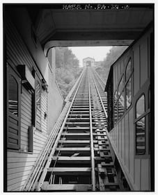
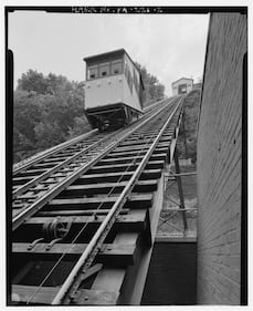
Mon Incline View looking up the tracks of the Monongahela Incline from the bottom. Picture taken in January 1970. (Archives & Special Collections, University of Pittsburgh Library System)
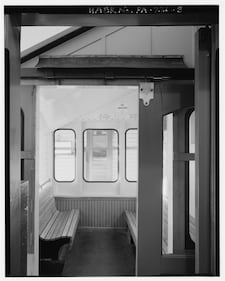
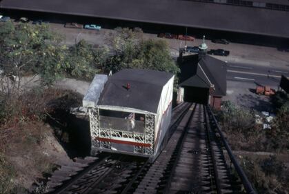
Mon Incline January 1970 view of one of the Mon Incline's cars. (Archives & Special Collections, University of Pittsburgh Library System)
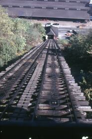
Mon Incline View looking down the tracks of the Monongahela Incline from the top. Picture taken in January 1970. (Archives & Special Collections, University of Pittsburgh Library System)
Mon Incline Caption on the back of the photograph reads, “The Monongahela Incline was opened May 28, 1870; the first Incline in Pittsburgh. Eventually, Pittsburgh had 17 Inclines. Now, only 2 remain; the Duquesne Incline and the Monongahela Incline. The Monongahela Incline was first operated by the Pittsburgh Railways Company, and in 1964 it was taken over by the Port Authority who operate it at the present time. It runs from Carson Street to the top of Mt. Washington which is a residential area. One-half Million People, commuters and visitors ride this incline each year.” The Monongahela Incline climbs a 35 percent grade, one of the steepest incline planes in the world. In 1970 it was declared a historic structure by the Pittsburgh History and Landmarks Foundation. In 1982 Port Authority made improvements to the incline with the replacement of car bodies, improved access, and renovated stations. In 1994 electrical and mechanical components of the machinery were replaced, trackway lighting was installed, and an addition was added to the upper station. (Detre Library & Archives, Sen. John Heinz History Center)