
PITTSBURGH — Showers and storms again moved through western Pennsylvania on Tuesday.
>>> PHOTOS: Severe storms move through western Pennsylvania as heat wave continues
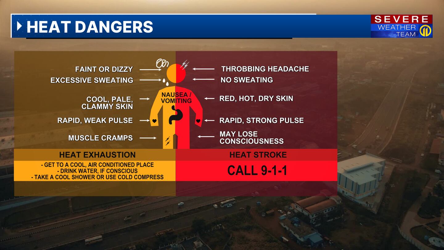
Some of the hottest weather in nearly 30 years continues this week, with the combination of heat and humidity pushing into dangerous levels. An Excessive Heat Warning has been issued for Allegheny, Beaver, Butler, Washington, Westmoreland and Fayette counties through Friday with heat index values forecast to climb as high as 100 to 105 degrees. Nighttime temperatures will also be unusually warm, offering little relief from the heat.
Isolated afternoon storms are possible again on Wednesday but should not be as widespread.
Stay weather aware by checking the live Severe Weather Team 11 forecast before heading out and have the Severe Weather Team 11 app with you for the latest Severe Weather Team 11 alerts as well as watches and warnings.
UPDATE 6/19/24 5:55 a.m.:
Duquesne Light and West Penn Power report about 12,600 customers are without power.
UPDATE 11 p.m.:
At last check, roughly 20,000 homes remain without power.
UPDATE 9:15 p.m.:
The National Weather Service said the threats in our area have diminished.
UPDATE 8:30 p.m.:
In an update to the media on Tuesday night, Duquesne Light Company said some communities could see their power restored as late as Sunday, potentially next week if heat-related issues continue.
“The estimated time of restoration for all customers is 1 p.m. on Sunday, June 23, with many customers expected to be restored sooner. Customers who remain without power should consider alternate arrangements to stay cool and safe — especially during this historic heat wave. With the potential for more storms and heat-related issues this week, the estimated time of restoration could move into next week.”
UPDATE 8:15 p.m.:
All warnings have expired at this time. Severe Weather Team 11 is continuing to monitor.
UPDATE 7:27 p.m.:
A Severe Thunderstorm Warning is in effect for northern Mercer County until 8:15 p.m.
Severe Thunderstorm Warning including Mercer PA, Stoneboro PA and Lake Latonka PA until 8:15 PM EDT pic.twitter.com/Hzp8WnQ5Bl
— NWS Pittsburgh (@NWSPittsburgh) June 18, 2024
UPDATE 6:30 p.m.
A Severe Thunderstorm Warning is in effect for southern Mercer County, Lawrence County and west central Butler County until 7:15 p.m.
Severe Thunderstorm Warning including New Castle PA, Hermitage PA and Sharpsville PA until 7:15 PM EDT. This storm will contain wind gusts to 70 MPH! pic.twitter.com/fH8oaP8DWy
— NWS Pittsburgh (@NWSPittsburgh) June 18, 2024
UPDATE 6:10 p.m.
A Severe Thunderstorm Warning is in effect for Northeastern Beaver County, Lawrence County and Southwestern Butler County until 6:45 p.m.
SEVERE THUNDERSTORM WARNING has been issued for the shaded portion of Beaver county. Take precautions now.
— Scott Harbaugh (@WPXIScott) June 18, 2024
Interactive radar: https://t.co/FZ9C6meUjq
Download the FREE Severe Weather Team 11 App for alerts: https://t.co/SNtbZ2FQ77 #WPXI #WPXIStorm #SevereWeather #PAWX pic.twitter.com/7i6C3bXrHH
UPDATE 5:30 p.m.
A Severe Thunderstorm Warning has been issued for Northwestern Mercer County until 6:15 p.m.
Severe Thunderstorm Warning including Greenville PA, Sharpsville PA and Reynolds Heights PA until 6:15 PM EDT pic.twitter.com/5OVCa3NBzx
— NWS Pittsburgh (@NWSPittsburgh) June 18, 2024
UPDATE 4:45 p.m.
A Severe Thunderstorm Warning has been issued in South Central Allegheny County and East Central Washington County until 5:30 p.m.
SEVERE THUNDERSTORM WARNING has been issued for the shaded portion of Washington county. Take precautions now.
— Scott Harbaugh (@WPXIScott) June 18, 2024
Interactive radar: https://t.co/FZ9C6meUjq
Download the FREE Severe Weather Team 11 App for alerts: https://t.co/SNtbZ2FQ77 #WPXI #WPXIStorm #SevereWeather #PAWX pic.twitter.com/MPVKqCkSue
UPDATE 4:30 p.m.
Channel 11 meteorologists are tracking a “very strong storm” moving over I-70 in the Spears area, tracking toward Charleroi.
Very strong storm moving over I-70 in the Spears area right now tracking toward Charleroi @wpxi pic.twitter.com/No90CP95ZN
— Stephanie Allison (@StephAllisonWx) June 18, 2024
UPDATE 4:25 p.m.
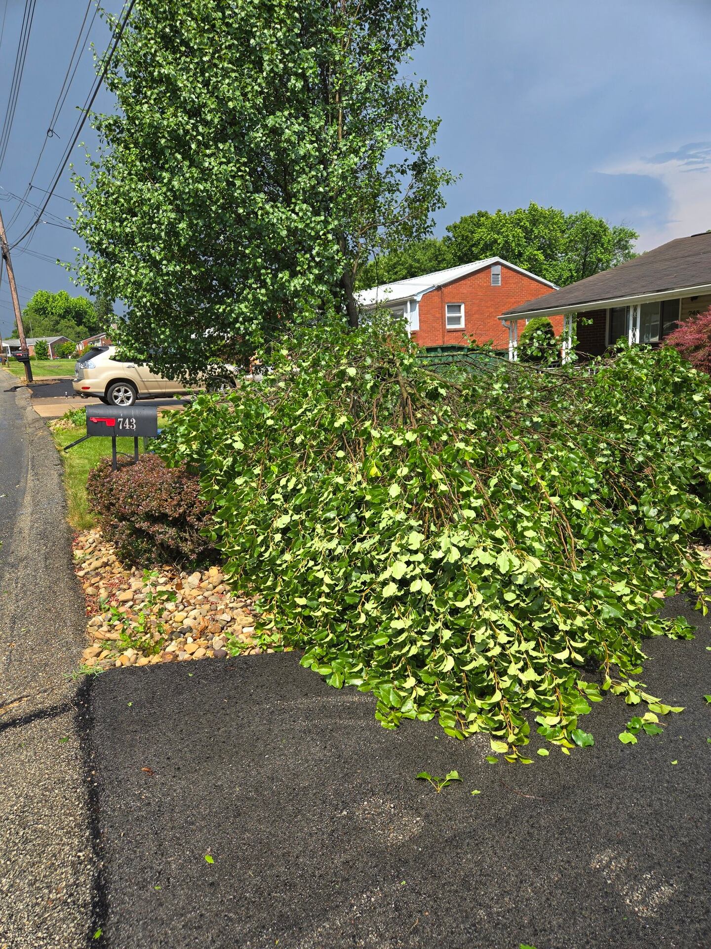
The NWS says trees and power lines are down between Brownsville and Perryopolis and asks people to use caution in the area.
Trees and power lines down between Brownsville, PA and Perryopolis, PA storm in Fayette County. Use caution in the area.
— NWS Pittsburgh (@NWSPittsburgh) June 18, 2024
UPDATE 4:20 p.m.
Channel 11 learned a person became trapped in a Plum home Tuesday after a tree fell on it. The fire department was able to get the person out of the home on Cassius Street, avoiding wires that were brought down. The person is not hurt.
UPDATE 4:15 p.m.
A Severe Thunderstorm Warning has been issued for Northwestern Fayette County, Southeastern Washington County and Southwestern Westmoreland County until 5 p.m.
SEVERE THUNDERSTORM WARNING has been issued for the shaded portion of Washington county. Take precautions now.
— Scott Harbaugh (@WPXIScott) June 18, 2024
Interactive radar: https://t.co/FZ9C6meUjq
Download the FREE Severe Weather Team 11 App for alerts: https://t.co/SNtbZ2FQ77 #WPXI #WPXIStorm #SevereWeather #PAWX pic.twitter.com/fTD9cfP7iR
UPDATE 4:07 p.m.
Viewer photos sent to Channel 11 show trees down on Providence Drive near Boyce Park in Plum.
UPDATE 3:56 p.m.
The NWS has issued a Severe Thunderstorm Warning for Western Fayette County and Southeastern Greene County until 4:45 p.m.
SEVERE THUNDERSTORM WARNING has been issued for the shaded portion of Fayette county. Take precautions now.
— Scott Harbaugh (@WPXIScott) June 18, 2024
Interactive radar: https://t.co/FZ9C6meUjq
Download the FREE Severe Weather Team 11 App for alerts: https://t.co/SNtbZ2FQ77 #WPXI #WPXIStorm #SevereWeather #PAWX pic.twitter.com/7X6p1JOUFm
UPDATE 3:55 p.m.
The NWS says there’s storm damage being reported in Plum and urges people to use caution in the area.
We have crews on the way to the area and will provide live updates on Channel 11 starting at 4 p.m. and on WPXI.com.
UPDATE 3:40 p.m.
In addition to power outages from Monday storms, more are being reported as thunderstorms move through on Tuesday.
Click here to see outages from Duquesne Light Company
Click here to see outages from West Penn Power
UPDATE 3:34 p.m.
The National Weather Service issued a Severe Thunderstorm Warning for Northeastern Allegheny County and Northwestern Westmoreland County until 4:15 p.m.
Severe Thunderstorm Warning including Plum PA, New Kensington PA and Lower Burrell PA until 4:15 PM EDT pic.twitter.com/T41u7Fmztf
— NWS Pittsburgh (@NWSPittsburgh) June 18, 2024
UPDATE 3:09 p.m.
A Severe Thunderstorm Warning was issued for parts of Allegheny and Westmoreland counties until 3:45 p.m.
Severe Thunderstorm Warning including Plum PA, Murrysville PA and Level Green PA until 3:45 PM EDT pic.twitter.com/7rcuXX4r2I
— NWS Pittsburgh (@NWSPittsburgh) June 18, 2024
ORIGINAL STORY
The heat wave will continue through the rest of the week with highs expected to be in the 90s at least through Saturday. The heat index will be close to 100 degrees every afternoon. A Heat Advisory remains in effect through Friday evening for several counties.
On Tuesday, the National Weather Service issued an Excessive Heat Warning for Beaver, Fayette, Washington, Allegheny, Butler and Westmoreland Counties until Friday evening. NWS says there could be maximum heat incides of 105-110 degrees. Temperatures in these counties will only drop to around 70-75 degrees at night.
Showers and storms are possible this afternoon through the early evening. The storms could become severe and produce damaging winds that could knock out power, and heavy rainfall that could lead to flash flooding, frequent lightning and hail. It’ll be very warm and humid overnight — temperatures will only fall to the low to mid-70s.
Make sure to be prepared and find ways to keep you and your family cool, watch for signs of heat-related illnesses during this hot stretch. Make sure to stay out of the sun, stay in air-conditioning, keep hydrated, and keep pets out of the heat.
Check the latest forecast on Channel 11 News. Make sure to download our WPXI Weather App for the latest updates and alerts.
Download the FREE WPXI News app for breaking news alerts.
Follow Channel 11 News on Facebook and Twitter. | Watch WPXI NOW
TRENDING NOW:
©2024 Cox Media Group